


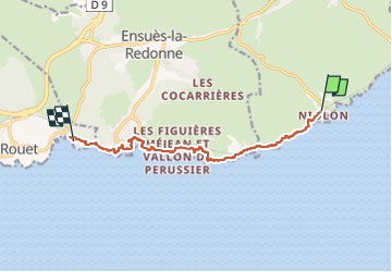
Gare de Niolon - Carry le rouet

JMJ42
User

Length
9.6 km

Max alt
65 m

Uphill gradient
269 m
Km-Effort
13.3 km

Min alt
3 m

Downhill gradient
298 m
Boucle
No
Creation date :
2025-03-01 12:40:42.563
Updated on :
2025-03-01 12:41:18.481
3h01
Difficulty : Difficult

FREE GPS app for hiking
 SityTrail
IGN / Geographical institutes
SityTrail Plus
The world is yours!
About
Trail Walking of 9.6 km to be discovered at Provence-Alpes-Côte d'Azur, Bouches-du-Rhône, Le Rove. This trail is proposed by JMJ42.
Positioning
Country:
France
Region :
Provence-Alpes-Côte d'Azur
Department/Province :
Bouches-du-Rhône
Municipality :
Le Rove
Location:
Unknown
Start:(Dec)
Start:(UTM)
682928 ; 4801078 (31T) N.
Comments